What to Know
- Tropical storm force winds extend outward up to 275 miles from the center as the storm could become named at some point on Wednesday
- South Florida remains slightly in the cone of concern, with a forecasted landfall predicted this weekend at the earliest
- Rainfall is expected to drop at least four inches across several Caribbean nations with as much as 10 to 12 inches expected in some areas
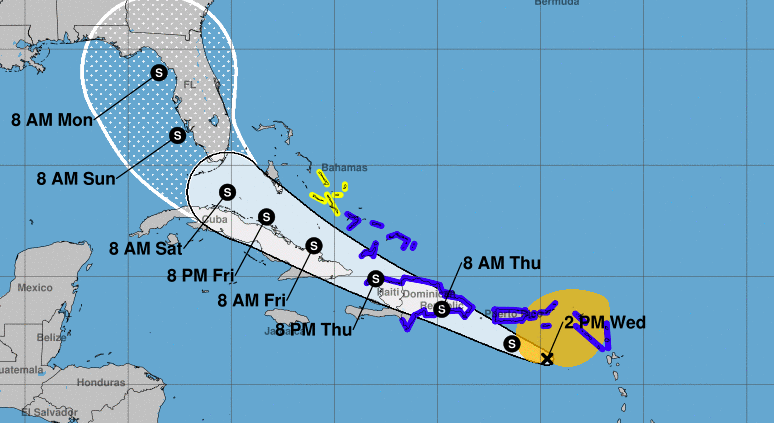
All eyes remain on the Atlantic Ocean and a system churning through the waters that could become the 2020 season’s next named storm as early as Wednesday - though South Florida may catch a break.
The 2 p.m. advisory on Potential Tropical Cyclone 9 shows the system has winds of 45 miles per hour and sits about 180 miles southeast of San Juan, Puerto Rico, with the system moving west-northwest at 23 miles per hour.
Stay up to date with NBC 6 First Alert Weather and South Florida's most powerful radar First Alert Doppler 6000 by downloading the NBC 6 app for iOS or Android.
A Tropical Storm Warning is in effect for Puerto Rico, southeast parts of the Bahamas, Turks and Caicos Islands, Vieques, Culebra, the U.S. and British Virgin Islands, Montserrat, St. Kitts, Nevis, Anguilla, St. Martin, St. Barthelemy, Saba, St. Eustatius and St. Maarten as well as parts of the Dominican Republic and the north coast of Haiti.
A Tropical Storm Watch is in effect for the Turks and Caicos Islands and central Bahamas.
Tropical storm force winds extend outward up to 275 miles from the center as the National Hurricane Center says the storm could become named at some point on Wednesday.
Some increase in strength is forecasted with the storm looking to push across and south of the Leeward Islands, then bear down on Puerto Rico on Wednesday night. Weakening is likely on Thursday due to land interaction, and some re-strengthening is possible later in the week.
South Florida remains slightly in the cone of concern, with a forecasted landfall predicted this weekend at the earliest. Once a much better organized center of circulation is identified, the accuracy will go up.
Rainfall is expected to drop at least four inches across several Caribbean nations with as much as 10 to 12 inches expected in some areas, including parts of Puerto Rico.
Officials in Puerto Rico expressed concern about the potential for landslides and flooding and urged people to take precautions. They noted the U.S. territory is struggling with a spike in coronavirus cases while also still recovering from 2017's devastating Hurricane Maria and a string of earthquakes earlier this year that damaged or destroyed hundreds of homes in the island’s south.
“We’re not facing a situation like Maria, but we have to remain wary,” said Pedro Janer, secretary of the Department of Public Safety.
At a news conference, Gov. Wanda Vázquez predicted the storm would cause power outages. Puerto Rico’s power grid was destroyed by Maria and the rebuilt system is fragile and susceptible to failures. Earlier Tuesday, the island’s power company and union leaders said electricity failed briefly for more than 450,000 customers when a plant was knocked offline for unknown reasons.
The governor said that more than 300 shelters across the island were prepared to receive people if needed and that more than 130,000 face masks were available.
“We’ve lived through several emergencies at one time,” Vázquez said. “I want you to remain calm.”
"still" - Google News
July 29, 2020 at 08:09PM
https://ift.tt/3jQjXrm
Florida Still in Cone as Tropical Storm Could Form; Puerto Rico Under Warning - NBC 6 South Florida
"still" - Google News
https://ift.tt/35pEmfO
https://ift.tt/2YsogAP
Bagikan Berita Ini


0 Response to "Florida Still in Cone as Tropical Storm Could Form; Puerto Rico Under Warning - NBC 6 South Florida"
Post a Comment