By GRACE KELLY/ecoRI News staff

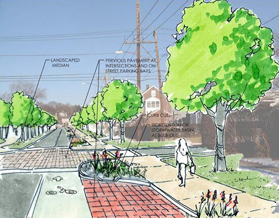
The Bicycle and Pedestrian Master Plan recommends traffic-calming measures and more signage, among other things. (Town of South Kingstown)
SOUTH KINGSTOWN, R.I. — The town is on a mission to transform its network of roads, highways, and byways into “complete streets.”
“Very simply, a street is ‘complete’ only if it’s built for everyone no matter who they are or how they travel,” C.J. Opperthauser, director of training and placemaking for Grow Smart Rhode Island, said during a presentation at the town’s Bike and Pedestrian Advisory Committee’s (BPAC) Jan. 21 online meeting. “So, no matter how you’re getting around, if it’s on your own two feet or it’s on a bicycle or if it’s on a scooter or a motor vehicle, whatever it is.”
To ensure that, moving forward, streets will be given this “complete” consideration, the BPAC formally unveiled its Bicycle and Pedestrian Master Plan at the meeting.
“We saw a tremendous interest in bicyclists and pedestrians as a protected class, if you will, when the South County Bike Path was built,” said Kenneth Burke, BPAC co-chair.
The creation of that bike path, which has taken 20 years to finish, prompted the town to adopt a complete streets resolution, but the current BPAC wanted to give that resolution more teeth.
“We decided that we would develop a comprehensive bicycle and pedestrian master plan,” Burke said. “It took us two years to get there.”
The 56-page master plan details a variety of statistics and goals, including improving the local bicycle and pedestrian network and recommending that any new roads built fit within the complete street model.
It cites a survey conducted by Deloitte Insights in 2017 that found that more than half the car trips taken annually in the United States cover less than 5 miles.
“If we have a well-designed, well-laid-out infrastructure where you could walk or ride your bike, you might actually think twice about jumping in your car,” Burke said.
Many of the residents in the virtual audience were on board with the idea of better connectivity for pedestrians and cyclists, with many commenting on how dangerous it is to trek along Route 1.
“I’m an avid cyclist. I’ve raced in most states in the country, and we see all the guys and gals that are riding on Route 1. We’ve got to get them off there and get them in a way that keeps them safe,” David Hayes said. “How can we get from … Ninigret to Narragansett without getting on Route 1 or at least having some isolation that can protect them.”
In addition to making connectivity a priority, the master plan also makes recommendations for immediate action, including adding traffic-calming measures to certain areas and intersections, asking the Rhode Island Department of Transportation to install “more visible warning signs, such as ‘No Turn On Red’ in the Dale Carlia intersection,” and installing speed radar signs in problem areas such as the Wakefield Main Street business district, Route 138, Middlebridge Road, and all bike path intersections.
“Ultimately, we want to make South Kingstown a safer place for everybody, not just folks in vehicles,” Burke said.
"complete" - Google News
January 26, 2021 at 05:01AM
https://ift.tt/3oiBVUj
South Kingstown Unveils Plan to Create 'Complete Streets' — ecoRI News - ecoRI news
"complete" - Google News
https://ift.tt/2Fvz4Dj
https://ift.tt/2YsogAP
Bagikan Berita Ini


0 Response to "South Kingstown Unveils Plan to Create 'Complete Streets' — ecoRI News - ecoRI news"
Post a Comment