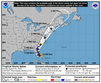
Isaias continued its crawl up the coast from Florida as a tropical storm Monday morning, staying relatively weak even as it headed for South Carolina.
As of 11 a.m., the storm was headed north off the coast of Florida at 13 mph, with sustained winds at 70 mph. The National Hurricane Center predicted Isaias would briefly swell into a hurricane as it passed warm water off Georgia's shore, then weaken again to a tropical storm upon making landfall in the Grand Strand area and rolling up the Atlantic coast.
"It's going to be a teetering thing ... a strong storm or really weak hurricane," National Weather Service Charleston meteorologist Rebecca Davidson said. "It's been an interesting storm, that's for sure."
Winds from the system were expected to begin pummelling the Lowcountry around noon Monday, and continue to the North Carolina border by 8 p.m.
Authorities issued a tropical storm warning for coastal portions of the lowcountry which weren't expected to suffer a direct hit. Futher north, a brief stretch of shore in the Carolians was under a hurricane watch.
Isaias blasted Puerto Rico as a tropical storm before speeding into a hurricane just north of Haiti and the Dominican Republic and rolling through the Bahamas as a Category 1 hurricane. Though the winds were relatively weak and quickly quashed by dry air, authorities had to evacuate the communities hit hardest by Hurricane Dorian in 2019, where many people still live in temporary shelters.
On Sunday and Monday, the system largely stayed out at sea as it traveled up Florida's length.
Meteorologists had expected Isaias, whose winds hovered around the 74 mph threshold that separates tropical storms from hurricanes, to strengthen again and hit Southeast Florida as an organized storm. But dry air and relatively cool water left the system slow, and it's brushed up the Sunshine State shore with relatively little damage.
The fluctuation doesn't indicate any surprising conditions, NWS meteorologist Mike Rowley said. Isaias has consistently hovered around 70 to 80 mph winds, staying near the 74 mph mark that denotes a hurricane.
"It's a matter of a few millibars, a few miles per hour," Rowley said.

"I'd be out here in the rain" said Robert Hayes who didn't have any concerns about incoming Tropical Storm Isaias as he spent the weekend fishing at the Folly Beach Pier Sunday, Aug. 2, 2020 "Ive got the umbrella!" Grace Beahm Alford/Staff
By Monday morning, experts predicted that portions of the Atlantic off Georgia's shore had up to 30 percent chances of seeing hurricane-force winds.
But the real impact will come from water, local meteorologists said. Storm surge should stay beneath 3 feet south of Edisto Beach, but could reach 4 feet in the Charleston area and 5 feet north of the South Santee river. Most the state has a slight risk of flash flooding, with moderate warnings along the Grand Strand coast.
The National Hurricane Center predicts up to 10 inches of rainfall in parts of the Palmetto State, though most of the coast will see 2 to 6 inches.
"There will be stuff outside the cone (and) in this case the flooding is going to be probably the worst part," Davidson said. "It could be a little bit north around high tide; it is going to come down to very particular timing."
Charleston and North Charleston have sandbag materials ready for residents, and Holy City residents can park for free until 8 a.m. Tuesday in the garages on Calhoun, Mary, St. Philip and Queen streets.
This is a developing story. Check back for more.
"still" - Google News
August 03, 2020 at 09:26PM
https://ift.tt/33iksVb
Tropical Storm Isaias could still become a hurricane before hitting SC - Charleston Post Courier
"still" - Google News
https://ift.tt/35pEmfO
https://ift.tt/2YsogAP
Bagikan Berita Ini


0 Response to "Tropical Storm Isaias could still become a hurricane before hitting SC - Charleston Post Courier"
Post a Comment